Land Nav Assistant app for iPhone and iPad
4.4 (
5824 ratings )
Navigation
Developer:
Gammon Applications
1.99 USD
Current version:
2.2, last update: 4 years ago
First release : 18 May 2012
App size: 36.21 Mb
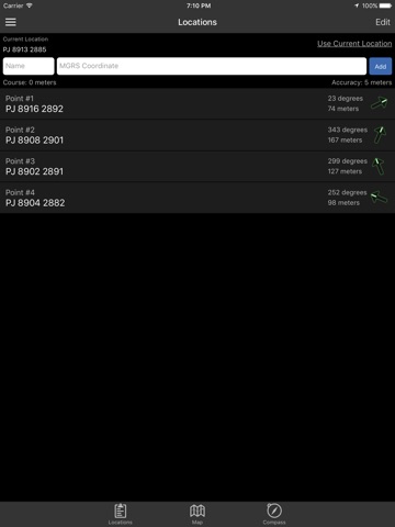
Land Nav Assistant accepts MGRS (Military Grid) or Latitude / Longitude coordinates and visually navigates you to each point.
This app was designed with Army, Marine, and other military personnel in mind. Use it to correct your Land Nav technique by analyzing your pace count and tendency to veer left and right.
Available Input: 8 digit MGRS, 10 digit MGRS, Lat/Lon decimal, Lat/Lon dms, and map input.
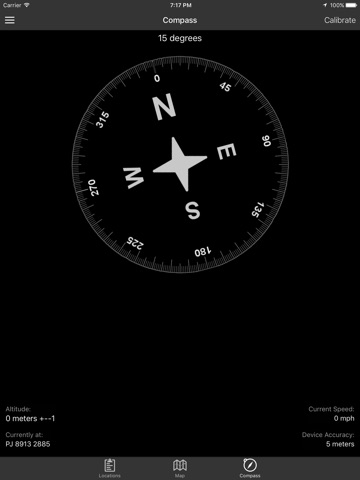
Angles: degrees or mils
Distance: meters/km or feet/miles
Speed: kph or mph
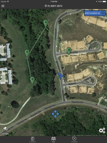
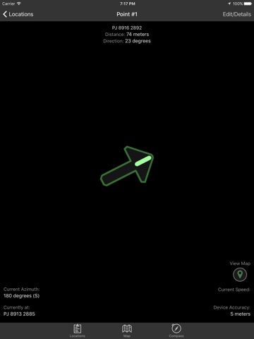
Use the simple arrow interface or map to direct you to your locations. Your distance, direction, speed, and bearing are shown as you navigate.
Long-tap anywhere on the map to get the coordinate for that location. Easily add locations via the Map interface.
Plan your course by ordering points, or use the course optimization tool which will help you calculate the shortest path possible!
Get distance/direction between two points by tapping the path drawn between them.
Satellite, Terrain, Road, and basic Topographic maps show you, your locations, and lets you enter in new ones.
Overlay a 1000m or 100m MGRS grid anywhere on the map.
Displays distance/direction from your currentl location to all points, or between any two points.
Download your Locations as a spreadsheet to save anywhere, or to share with anyone you choose.
Import a large set of locations via the web import utility, available at: https://www.gammonapplications.com/land-navigation-services/import
This app uses the Military Grid Reference System (MGRS) and Latitude / Longitude.
Choose to display your locations as MGRS 10-digit, MGRS 8-digit, or LatLon Decimal.
D:M:S can be input in the format DD:MM:SS followed by the appropriate direction (NSWE). Default direction is N, W.
DO NOT use this application while learning Land Navigation. Land Navigation is a valuable skill, and should be mastered before using this application. Do not rely solely on this application for navigation, especially when lost. Always be aware of your surroundings.
Pros and cons of Land Nav Assistant app for iPhone and iPad
Land Nav Assistant app good for
Punch in the grid and your off. Gets you were your going with ease. Would recommend to anyone for assistance with land Nav.
Used this both before deployment and during. Works really well. Was able to pull up coordinates faster than my dagr, and got me to every point I needed.
Would like to edit points and change colors of pins. 5 stars.
Some bad moments
Almost perfect accuracy. Simple and easy to use. I sprinted through my last land nav course and got 5 out of 5.
From my experience as a scoutmaster, land surveyor, and youth leader-- this is a great app for simple, reliable and accurate navigation outdoors or to off the grid locations Google Maps cant find.
Works great on the division land nav course on ft Campbell, ky
While the app does work, a 10 digit grid is actually an 8 digit grid when you have to input the grid designator. 8 digit gets you within 100m of your point. Which in thick forest looking for a specific point, a white ammo can in this case, is useless. If it was a true 10digit gps, this would be the best land nav app out there.
This app worked flawlessly for me. 8 digit grids are actually within 10m not 100 as a previous review stated (hence the reason it says accurate within 10m) and if you cant find a point standing within 10m of it, thick forest or not, then there isnt much hope for you anyway! Great app, love the feature where you can press on your points and it gives an arrow pointing where you need to go and how many meters left. Does exactly what it says no more no less.
Theres no other app out there like this one. Just plug in ur grid of where your at and the grid of where you need to be and it literally tells you the azimuth u need to walk and for how long. And u can always change the grids at anytime! Devs if this app could get any better than what it is ie.( show line on Map from the different points to give us a better sound picture of a visual of how long the two or more points are from each other would be cool) as an option! All in all I recommend this to everyone!
Usually Land Nav Assistant iOS app used & searched for
grid coordinates,
Land Nav Assistant,
military grid,
and other. So, download free Land Nav Assistant .ipa to run this nice iOS application on iPhone and iPad.